My HEC-RAS Wish List
Please note: All continuing education resources previously listed at surfacewater.biz have moved to hydroschool.org; going forward, the surfacewater.biz website will be dedicated to drainage-related consulting work only.
Check out our updated HEC-RAS wish list at hydroschool.org/wish/.
Below is the archived page:
This page serves as a repository for bug fixes and other suggestions compiled from ongoing HEC-RAS course attendees. The RAS Solution Forum has existing threads for HEC-RAS bugs and suggestions, so there’s no need to post a comprehensive list of proposed fixes here, but I thought I’d list some of the items that come up most frequently during our HEC-RAS courses.
The idea behind this list is to provide workarounds or updates on fixes for course attendees wherever possible rather than serving as a complaint board; so if you have figured out a way around one of the listed issues, please let me know how you’ve managed, and I’ll update this post.
Some of these items may have already been addressed in the most recent versions, so if you run across anything in this list that is outdated please contact us.
HEC-RAS Glitches and Fixes
Wish List:
- Automatically update geometry viewer backgrounds with RAS Mapper updates
- hdf errors related to Windows Regional Settings: workaround is to change regional settings to English US in the error message.
- Save As. If you use “save as” to make a backup copy or new version of your project, RAS Mapper sometimes loses projection or terrain and land use associations. (WORKAROUND: If you want to back up files or save a copy in which everything appears the same, you’ll need to copy and paste the entire folder, then delete what you don’t need. Or use zip plans or archive project menu item)
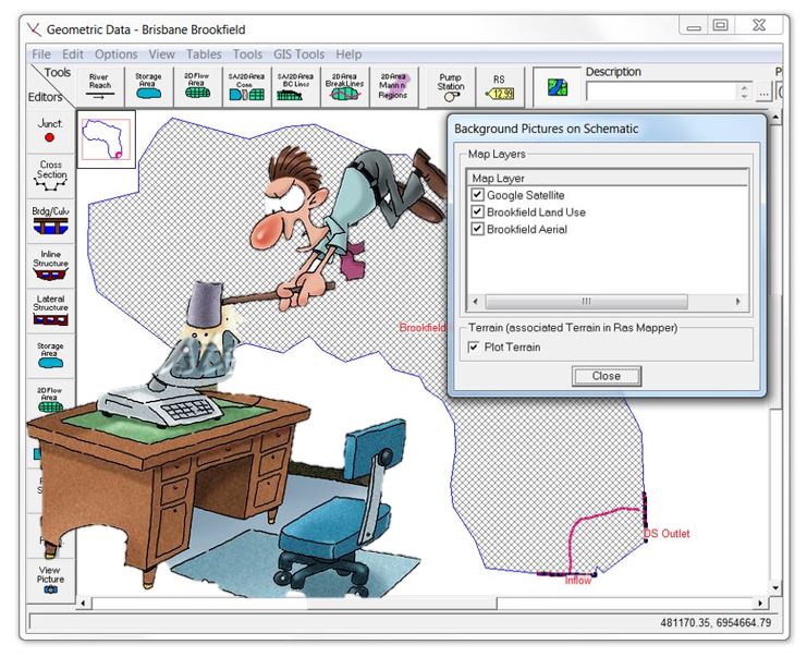
- Cache Errors. Some errors, including certain versions of the 157 code error, simply can’t be resolved with changes to your model geometry, flow, or plan files. (WORKAROUND: 1. Save the project, 2. Close and re-open HEC-RAS, 3. Re-run the plan.) This seems to solve 90% of the errors, which I assume is a cache issue; if HEC-RAS could automatically clear the cache when plans are run, maybe some of these errors would disappear. It may seem obvious to pick the lowest-hanging fruit on the troubleshooting tree by taking this approach, but if you try to solve things any other way and stop short of exiting the program entirely, you can spend hours troubleshooting errors that you’ll never actually be able to solve! I’ve done that myself… and when I finally tried restarting HEC-RAS and my model ran just fine with no other changes, I felt a bit like this guy:
Following are some capabilities I am hoping we will see in future releases to get past some of the current computational limitations:
- Depth-varying roughness. Models with significant shallow water areas and high depth variability can have massive uncertainties associated with roughness values. (WORKAROUND: This tutorial video includes a limited workaround (with no temporal variation).
- Integer values for flood hazard mapping
- Transmission losses. Direct rainfall models would greatly benefit from the ability to enter initial and continuing losses, particularly if spatially varying loss rates could be entered within each 2D Flow Area. (WORKAROUND: This is reportedly coming in Version 5.1; in the meantime, you can partially get around this limitation by entering rainfall excess only, with infiltration removed manually, but keep in mind that areas with ponded/concentrated flow will react differently from dry areas in models that incorporate infiltration, yielding different total runoff volumes between the two approaches.)
- Show bridges in RAS Mapper
And here are some suggested editing features to add:
- Ctrl/Shift to operate on multiple items at once. This includes deleting geometry/plan/flow files, profile lines (especially if you accidentally import a shape file with hundreds of features!)
- Ctrl Z to Undo in Geometric Data Editor. “What? There’s no undo?” is probably the #2 complaint after the disappearing terrain. (WORKAROUND: Not a great solution, but if you’re working on something time-consuming in your geometry, save as and save often.) [Undo was added to RAS Mapper in Version 5.0.4]
- One of the main requests for the undo command is while creating a geometric feature. In RAS Mapper you can undo the creation of individual vertices while features are being delineated, but it would be nice if it could apply to any mistake you might make, especially when you delete a feature that you want to get back! (WORKAROUND: I create everything geospatial in CAD or GIS so that it’s recoverable, “undo-able”, fully editable, and importable into HEC-RAS)
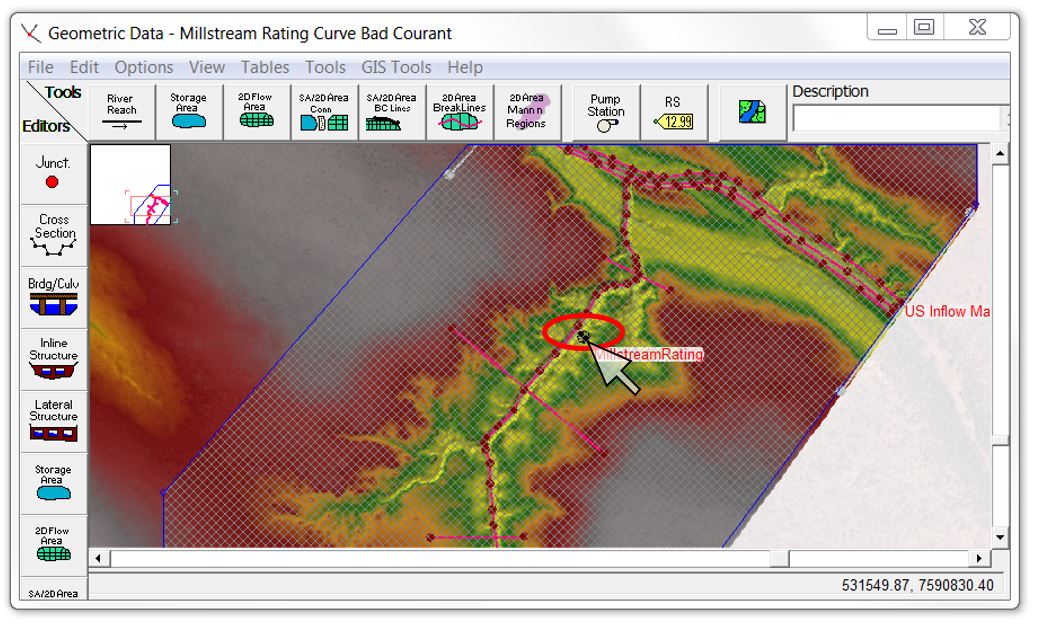
- If you accidentally move the entire 2D Area, which can occur when the handle happens to appear right next to another vertex that you actually meant to move, you will really wish for an undo option! (WORKAROUND: Similar to the above, I like to keep 2D boundaries and other critical features in CAD/GIS applications so that they’re editable outside of HEC-RAS; then if you make a mistake and accidentally move your area, you just copy and paste the coordinates back in. Alternatively, you may want to just keep an Excel workbook and paste the coordinates there for later use or recovery). In my opinion, moving the 2D Flow Area should get its own “Are you sure you want to do this” prompt before it is applied. You may not even realise the 2D Flow Area has moved until you’ve made a number of other edits to your geometry. The cross-hair symbol is appropriate here, because you can shoot your model in the head by moving the 2D area: Realigned cells won’t line up with breaklines, boundary condition locations will be off, etc. So avoid this one at all costs and don’t touch the cross-hairs unless you really, really mean to! Here’s a screen shot showing the dreaded handle for the 2D Flow Area in dangerously close proximity to a breakline vertex:
- Zoom commands (this one comes in a close third for the bronze!)
- In both RAS Mapper and the Geometric Data Editor, allow the escape key to toggle off the current edit or zoom commands and go back to a selection arrow (rather than manually having to de-select the command from the dropdown menu or tool button, similar to AutoCAD and other CAD/GIS applications)
- Allow the middle mouse button to pan and zoom on the fly while delineating features in Geometric Data Editor
- Make pan, measure, and other view commands consistent between RAS Mapper and the Geometric Data Editor (especially the CTRL and Shift key combos)
- Automated geometry adjustments (#1 potential time saver!)
- Run all terrain fixes (perhaps with a prompt if more than say ten iterations are required
- Automatically lift embankment elevations to at or above the corresponding cell elevations (typically the required change is only a few millimetres and currently requires manual adjustment or a uniform shift that may impose an artificial weir – again, with a prompt asking if you want the program to make the adjustment automatically)
- Automatically lower the terrain elevation to at or below the assigned culvert invert or embankment elevation (again, this would require a prompt with a choice of how to make the adjustment since you may prefer to change the embankment elevation as described above)
- Automatically update all results layer names, legend names, folder names, etc. when short IDs are renamed in a plan (currently you have to re-run your plan to get the layer names to update)
- Alternatively, allow users to right-click on the results file name to rename the plan in RAS Mapper like you can do with shape files, images, etc.
- Generate a shape file or display error locations automatically (instead of having to grab cell ID numbers from the error log and search for them manually)
- Allow terrain modifications using shapefiles or strings with elevations (this would make it much easier to extrude buildings or floodwalls or dig detention basins into terrain surfaces – any TUFLOW user will constantly be looking for zsh/zpoly lines that can do the trick!)
- In hydrographs, hyetographs, and GIS tables, allow the bottom right corner of a cell to be dragged down to paste values to cells below (like is allowed in profile tables similar to Excel capabilities)
Other suggestions:
- File Extensions. Call the HEC-RAS project file extension something other than .prj to avoid confusion with ESRI projection files. I’ve been told it’s way too late to fix this, but if HMS project files can be .hms, why can’t HEC-RAS projects be .ras or .hrp or something similar? I always keep shapefiles in their own subfolder, but when I try to search a parent directory for HEC-RAS projects, the search returns a prj file for every single shapefile in my folders – sometimes hundreds – in addition to my HEC-RAS projects. If it truly is too late to change this, maybe HEC-RAS can include a customised search tool under the “Open” command that recognises the HEC-RAS project file type and returns only those results in a search.
- Highlights
- The projection being used (or even just whether or not a projection has been assigned) should be shown big and bold along the top bar in RAS Mapper
- The equation set being applied (Full Momentum vs. Diffusion Wave) should be shown big and bold on the unsteady plan window in my opinion. Since you can have multiple 2D areas with different equation sets, there would need to be an option of showing that both are being used in a particular run, but given the potential implications of using an inappropriate equation set, it would be nice to see what’s being used without digging through the options. Some users mistakenly think that setting the default equation set will change the default in new projects (it only changes the default for new 2D Flow Areas within the same project).
- Add the units of measure to the errors in the runtime messages
- Dropdown lists
- When adding new terrain, only three file types show up (tif, flt, and adf), yet HEC-RAS will recognise many more – dozens, in fact, if you look at the list in the back of the 2D manual. You won’t see them, however, unless you lower the drop-down list to show all types. Why even limit things with the first list of three?
- The same concept applies to images under map layers; you won’t see them unless you drag down the drop-down list of file types. Why limit it? Why not just show everything you can add right there at once?
- Defaults
- Equation Set. Some users have assumed that the default equation set will apply to new projects rather than just new 2D Flow Areas within the current project. It would be nice to be able to set the default for HEC-RAS as a whole, so that you could set all new 2D Flow Areas to Full Momentum if desired.
- 1D/2D Iterations. The program defaults to 0 iterations between 1D and 2D. This looks like an oversight, since most other iterations values default to 20, but maybe it’s intentional so users will check your interfaces closely.
- Computational Time Step. When you first install the program, the default computational time step is 1 hour. Again, maybe that’s intentional so that you’ll remember to always check your Courant Number, but I can’t imagine any hydraulic model (other than perhaps a quasi-unsteady sediment transport model) running at a 3600-second time step. If you targeted a Courant Number of 1, typical velocities of 2 m/s would give you a 7-km x 7-km grid size. That’s a 50 km2 grid, which certainly wouldn’t give any meaningful results in any model I’ve ever seen. I would think the default should be on the order of a few seconds at most to be more reasonable for typical mesh sizes.
- RAS Mapper views:
- Speaking of defaults, the RAS Mapper legend defaults to absurdly high or low values:
- 15-metre depth, which is way too high for most river systems (I always reset this to a much lower max value, especially since particle tracing won’t show up with any contrast unless there’s some dark blue beneath it)
- 15 m/s velocity, which is way too high for most river systems (I usually reset this to around 2-4 m/s to show anything meaningful)
- 5 Pa shear stress, which is way too low for most river systems (I usually reset this to around 200 Pa to show any meaningful results)
- Allow transparency to be defined by a percentage rather than just the graphical slide bar to allow consistent display between layers
- Keep the profile axes fixed during animations instead of jumping around, or at least allow the axis scales to be customised similar to 1D graphing capabilities (WORKAROUND: WaterRIDE’s beta version is just about there with this capability – we’ll update this post when it’s available)
- Allow animation of multiple profiles (currently only one profile will animate, while the rest stay stuck on the original time step)
- Allow contours to be exported as vector shape files. (Perhaps this is covered under “contour bands” which can be exported from a terrain file and then added as a map layer? I’ve tried to do that but got no viewable results and can’t find any documentation on the command. Looking for help on this one if you’ve used it.)
- Allow the measure tool (CTRL-click) to be used in RAS Mapper to get the slope off a profile line like is allowed in profiles cut from terrain in the Geometric Data Editor
- Add a moving vertical bar on time series plots that shows where you are in your plan view animation
- Add depth difference map as display/export option [WORKAROUND: currently available for WSEL in RASter calculator]
- Maybe a shot in the dark, but until QGIS can correctly read hdf files with the Crayfish plugin, I would love to have a way to record animations and control the frame rate for the output file. If you use screen capture software you can’t speed it up past zero delay unless you manually move the slider…in which case the animation comes out very choppy. (WORKAROUND: Sounds like WaterRIDE is just about there with the ability to do it – I’ll post an update once that’s confirmed.)
- Speaking of defaults, the RAS Mapper legend defaults to absurdly high or low values:
- Consistency between RAS Mapper and Geometric Data Editor
- Allow flood extents to be automatically viewable in the Geometric Data Editor along with the shape files. (WORKAROUND: this can be done by adding the flood extent map layer and converting the extents to a vector shape file under Map Layers in RAS Mapper and/or adding the raster results as a terrain file, but it would be nice to have it automatically available while you’re editing/refining geometric features such as breaklines and structures).
- Combining RAS Mapper and the Geometric Editor into the same interface would avoid all of these issues with consistency, but that’s of course a major overhaul!
- Apply shape file roughness coefficients to 1D models
Perhaps someday we can look forward to a future software package that combines RAS and HMS into a single interface! But I’ll stop there before we get too far ahead of ourselves! Adding some of the suggested capabilities would obviously take a major amount of effort to build in, but I’m guessing if you turned a programmer loose with the code, quite a few of these suggestions could be incorporated in just a few minutes of code writing and compiling.
I have to acknowledge that some of these items may not be program issues, but rather my own ignorance in not knowing where to find the solutions. Contact me if you have any corrections, updates, or other suggested workarounds, because I’d like this to be a solutions page rather than a problems page. In the meantime, I’ll keep updating this list with feedback from our courses.
Krey Price
Surface Water Solutions


